Mendocino Triple Junction
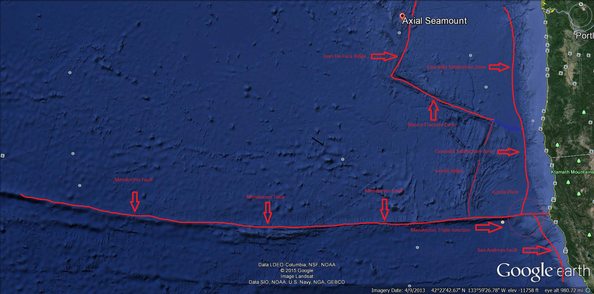
Diagram of the Mendocino Triple Junction
The Mendocino Triple Junction is one of the most active regions where the San Andreas Fault meets the Mendocino Fault and the Cascadia subduction zone, separating three tectonic plates. There is the Pacific Plate, the North American Plate, and the Gorda Plate, which is located just offshore off Cape Mendocino in Northern California. It is one of the most seismically active regions of the San Andreas transform system. Since 1983 the region has generated about 80 greater than or equal to Magnitude 3.0 quakes each year, and historically the region has experienced major quakes. This activity is generated in response to ongoing plate motions between the Gorda, North America, and Pacific Plates.
The Mendocino Fault or Mendocino Fault Zone is a fracture zone and transform boundary off the coast of Cape Mendocino in far northern California. It runs westward from a triple junction with the San Andreas Fault and the Cascadia subduction zone to the southern end of the Gorda Ridge. It continues on west of its junction with the Gorda Ridge, as an inactive remnant section which extends for several hundred miles.
Technically, a fracture zone is not a transform fault, but in the case of the Mendocino, the term has been loosely applied to the active fault segment east of the Gorda Ridge as well as to the true fracture zone segment west of it. The fault section demarcates the boundary between the northwestward-moving Pacific Plate and the eastward- moving Gorda Plate. The Gorda Plate is subduction beneath the North American Plate just offshore of Cape Mendocino. Where the Mendocino Fault intersects the undersea trench of the subduction zone, it also meets the San Andreas Fault. This seismically active intersection is called a triple junction, and specifically the Mendocino Triple Junction.
The Cascadia Subduction Zone runs from triple junctions at its north end and south ends. To the north, just below Queen Charlotte Island, it intersects the south, just off of Cape Mendocino in California, it intersects the San Andreas Fault and the Mendocino fault zone at the Mendocino Triple Junction.
Recent findings concluded the Cascadia subduction zone was more hazardous than previously suggested. The feared next major earthquake has some geologists predicting a 10% to 14% probability that the Cascadia Subduction Zone will produce an event of magnitude 9 or higher in the next 50 years; however, the most recent studies suggest that this risk could be as high as 37% for earthquakes of magnitude 8 or higher. Geologists and civil engineers have broadly determined that the Pacific Northwest region is not well prepared for such a colossal earthquake. The tsunami produced may reach heights of approximately 30 meters or 100 feet high. The earthquake is expected to be similar to the 2011 Tohoku earthquake and tsunami, and the rupture is expected to be as long as the 2004 Indian Ocean earthquake and tsunami.
San Andreas Fault is a continental transform fault that extends about 810 miles through California. It forms the tectonic boundary between the Pacific Plate and the North American Plate, and its motion is right-lateral strike-slip (horizontal).
The southern segment of the San Andreas Fault begins near Bombay Beach in California.The fault runs along the southern base of the San Bernardino Mountains and crosses through the Cajon Pass and continues northwest along the San Gabriel Mountains. As the fault continues in a northwestern direction from Parkfield to Hollister, through the Santa Cruz Mountains, then on up the San Francisco Peninsula, then offshore at Daly City near mussel rock. The fault returns onshore at Bolinas Lagoon just north of Stinson Beach in Marin county. It returns underwater through the linear trough of Tomales Bay which separates the Point Reyes Peninsula from the mainland, and runs east of the Bodega Heads through Bodega Bay and back underwater, returning onshore at Fort Ross. From Fort Ross it continues overland, forming in part a linear valley through which the Gualala River flows, and goes back offshore at Point Arena. After that it runs underwater along the coast until it nears Cape Mendocino, where it begins to bend to the west, terminating at the Mendocino Triple Junction.
The Gorda Plate is located beneath the Pacific Ocean off the coast of Northern California, and is one of the northern remnants of the Farallon Plate. Unlike most tectonic plates, the Gorda Plate experiences deformation inside its boundaries. Numerous faults have been mapped in both the sediments and basement of the Garda Basin, which is in the interior of the plate. Stresses from the neighboring North American Plate and Pacific Plate cause frequent earthquakes in the interior of the plate.
The easterly side is a convergent boundary subducting under the North American Plate in northern California. The southerly side is a transform boundary with the Pacific Plate along the Mendocino Fault. The westerly side is a divergent boundary with the Pacific Plate forming the Gorda Ridge. The northerly side is a transform boundary with the Juan de Fuca Plate, the Blanco Fracture Zone.
The subducting Gorda Plate is connected with the volcanoes in northern California, namely, Mount Shasta and Lassen Peak which last erupted in 1914 – 1917.
The Pacific Plate is an oceanic tectonic plate that lies beneath the Pacific Ocean. At 103 million square kilometers, it is the largest tectonic plate. The north-eastern side is a divergent boundary with the Explorer Plate, the Juan de Fuca Plate and the Gorda Plate forming respectively the Explorer Ridge, the Juan de Fuca Ridge and the Gorda Ridge. In the middle of the eastern side is a transform boundary with the north American Plate along the San Andreas Fault, and a boundary with the Cocos Plate. The south-eastern side is a divergent boundary with the Nazca Plate forming the East Pacific Rise. The Pacific Plate contains an interior hot spot forming the Hawaiian Islands.
What is a tectonic plate? A tectonic plate (also called lithospheric plate) is a massive, irregularly shaped slab of solid rock, generally composed of both continental and oceanic lithosphere. Plate size can vary greatly, from a few hundred to thousands of Kilometers across, with the Pacific and Antarctic Plates are among the largest.
Most of the boundaries between individual plates cannot be seen, because they are hidden beneath the oceans. Yet oceanic plate boundaries can be mapped accurately from outer space by measurements for GEOSAT satellites. Earthquake and volcanic activity is concentrated near these boundaries. Like many features of the Earth’s surface, plates change over time. Those composed partly or entirely of oceanic lithosphere can sink under another plate, usually a lighter, mostly continental plate, and eventually disappear completely. This process is happening now off the coast of Oregon and Washington. The small Juan de Fuca Plate, a remnant of the formerly much larger oceanic Farallon Plate, will someday be entirely consumed as it continues to sink beneath the North American Plate.
footnote: The recent discovery in April from a team of scientist about a new eruption of the Axial Seamount which is an undersea volcano. It is located about 250 miles off the Oregon coast and about 200 miles west from the very dangerous Cascadia Subduction Zone and only about 425 miles north from the very active Mendocino Triple Junction. The Axial Seamount is the youngest and most active site in the North Pacific Ocean. The Axial Seamount is part of the Cob-Eikelberg Seamount chain, which is a chain of seamounts that terminates south of Alaska. Axial Seamount lies where the chain intersects the Juan de Fuca Plate and the North American Plate, offset by the Blanco Fracture Zone to the south.
